The Gulf Stream
Why Louisiana?
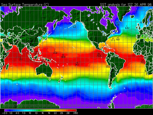
The above image depicts a rough diagram of the ocean's temperatures, from coldest (purple) to warmest (red). The region in red is called the Gulf Stream and it represents a warm and rapid current that transfers heat and salt in a northeastern direction at a rate of 30 million cubic meters per second. It is located at the boundary between the Trade Winds and the Westerlies; the friction between these two wind patterns creates an increase in heat. The region extends from the Caribbean to the Northern Atlantic Ocean and its exact latitudinal position changes throughout a given calendar year. During the northern hemisphere's summer, the Gulf Stream moves north--this means that the warm water currents move closer to the southern coast of the United States in the summer months.
As you learned in the Hurricane Mechanics section, hurricanes form because of the warm, moist air above oceans (specifically, the ocean temperature must exceed 26.5 degrees Celcius). So, this warm ocean region is ideal for the formation of hurricanes. In fact, 80% of hurricanes in the Gulf region occur in September, when the Gulf Stream has moved north and is nearer the coast.
Frequency of storms:
To give you an idea of the prevalence of this hurricane problem, it is important to realize how often these storms affect the region of the United States nearest the Gulf Stream. Between 1901 and 1997 alone, there were 55 recorded hurricanes. This averages out to approximately one hurricane every three years!
Click on this website to read more about the hurricanes that have struck the Gulf Coast region throughout history:
http://www.hpc.ncep.noaa.gov/research/lahur.pdf
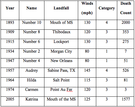
Table of Gulf Coast hurricanes with
the highest death count since 1893:
Check it out:
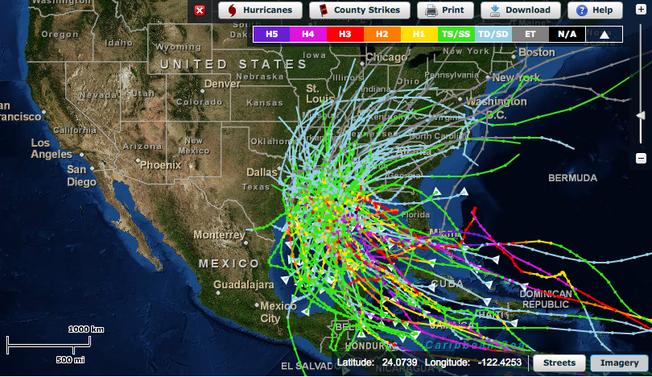
Each colored line on this map represents the path of a hurricane that has made a landfall somewhere in Louisiana between 1892 and 2010. The color represents the category of the storm and the triangles show the point of origin.
The Gulf Coast is at risk and we need to pay attention!
Did you know?
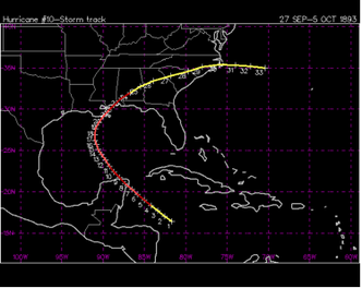
The deadliest hurricane in Louisiana's history occurred in October of 1893. Referred to as the Chenier Caminanda Hurricane, this Category 4 storm originated in the Gulf region, hit the coast of Louisiana, and continued to move in a northeast direction through the United States. The greatest amount of damage was done to the Chenier Caminanada Island between New Orleans and Port Eads. 100 mph winds and a 15 foot storm surge completely wiped out islands and resulted in the death of approximately 2,000 people (779 from Chenier Caminanda alone).
The deadliest hurricane in Louisiana's history occurred in October of 1893. Referred to as the Chenier Caminanda Hurricane, this Category 4 storm originated in the Gulf region, hit the coast of Louisiana, and continued to move in a northeast direction through the United States. The greatest amount of damage was done to the Chenier Caminanada Island between New Orleans and Port Eads. 100 mph winds and a 15 foot storm surge completely wiped out islands and resulted in the death of approximately 2,000 people (779 from Chenier Caminanda alone).
